


Koto ward Project 1
Case Study 1 : Redevelopment for High Density Urban Areas in Koto-ward, Tokyo
The City of Tokyo faces water-related disasters due to global climate change, such as water shortages arising from the reduced rainfall during dry summers and flooding from concentrated heavy rain in restricted regions cannot be ignored. In many cases, flooding resulted from the land in urban areas being almost completely covered with concrete and asphalt, preventing rain seepage into the underlying soil. This situation also brings about the problem of overheating in cities that we call the "Urban Heat Island" syndrome.
Furthermore, there is the danger of a massive and destructive earthquake hitting the Tokyo area in future. The biggest threat from earthquakes is from fires breaking out following a seismic disturbance. It was almost impossible to bring the fires under control because of the damage to the water as well as the electric power supply resulting from the earthquake.
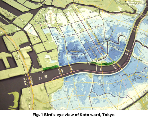
Koto Ward of Tokyo is located in a low-lying district called the Koto Triangle between the Sumida River and the Arakawa River and is bound by Tokyo Bay (See Fig.1). The project site is located approximately 3 km from the mouth of Tokyo Bay. The area of Koto Ward used to be one of the most prosperous suburban industrial sites in Tokyo, and a substantial quantity of underground water was pumped up through wells, further encouraging land subsidence. Since then, the situation has remained highly critical. Today, two thirds of the total area of Koto Ward is lower than the average sea level of Tokyo Bay as is shown in Fig.1.
The population in 1957 was 300,000, but, by end of 2010, this had grown to more than 470,000. The total land area of Koto Ward is 39.9 k㎡ and its population density is 117.79 persons/ha. There are huge warehouses of logistic companies side by side with private dwellings in the residential areas. The project site in particular is characterized by narrow and disorganized streets with few parks, giving it the impression of random development. If a huge tsunami and/or fire due to a large earthquake were to occur, the status here would become highly critical.
The water city plan for Koto ward, Tokyo covers an area of approximately 2 km from north to south and between 0.5 and 1.0 km east to west, with a total land area of approximately 1.25 km2. The population is nearly 27,500 people and the area consists of 12,600 households and there is a population density of 223.6 persons /ha. The plan includes the development of a mid-to high-rise housing area (approx. 560 persons /ha) and a waterfront as an open space that occupies nearly half of the total area being developed (625,000 m2 or 22.7 m2 /person). The planned population, which is set at its current size between 27,000 and 30,000 people, is three times the size of that of its neighboring communities (8,000 to 10,000 people). In accordance with these demographic proportions, the project site constitutes a mid-sized city that will require three elementary schools and one junior high school. In addition to its residential functions, various urban facilities are being taken into consideration to enliven the city (See Fig. 2). These include: (1) a shopping complex necessary for comfortable living, (2) an aggregated industrial site for small workshops, (3) an aquatic resort space along the Arakawa River, and (4) an office complex. The bird's-eye view of the water city is shown in Fig.3.
![Various urban facilities for water city [WATERPOLIS]](../images/projects/photo2.jpg)
![Bird's-eye view of water city [WATERPOLIS] for Koto ward, Tokyo](../images/projects/photo3.jpg)
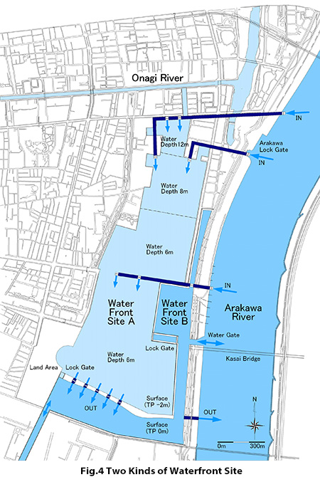
The waterfront to be developed in this Koto Ward project is divided into two sections (See Fig. 4). Waterfront Site A (0.85 km2) on the inland side is completely isolated from the Arakawa River and the Tokyo Bay. At present, in the east area of Koto Ward where the ground level is very low, the surface level of the water channels is adjusted to some 2 m below the average surface level of the Arakawa River. Waterfront Site A is designed to link those channels, including the Onagi River. The connection with the Onagi River will enable the free and extensive transportation of people and goods throughout the community regardless of tide level. Waterfront Site B (0.34 km2) is a narrow inverted L-shaped area. Boats travel to and from the Arakawa River by way of water gates that remain open except during emergencies such as the tsunami transmission. Although the water level in Waterfront Site B is directly affected by the tide level, its merit is that boats are able to move to and from the Arakawa River and the Tokyo Bay freely without passing through a lock gate.
Because Waterfront Site B connects directly with the Arakawa River and Tokyo Bay, the water level in Waterfront Site B is almost at sea level and is therefore hardly affected by the discharged water. The quantity of water discharged to Waterfront Site B by the axial flow pumps is subject to seasonal change, depending on seasonal increases due to heavy rain for example. In the case of a rainfall of 50 mm/h, the overall rate of rainfall in 1 km2 is 13.9 m3/s (no more than 28 m3/s in case of 100 mm/h rainfall), which is within the capacity of 5 axial flow pumps (12 m3/s per pump). Solar energy supplies the power to activate the pumps and other facilities. It is possible that the flow of water to Waterfront Site A may stop for certain period of time due to a shortage of electric power, however, no large problem is anticipated as a result of this. In fact, the use of solar energy as a power source to purify and pump water takes advantage of natural energy and thereby shares a common viewpoint with the windmill system used in the Netherlands to drain excessive inland water.